ChinaKnowledge.de -
An Encyclopaedia on Chinese History and Literature
Jiangnan jinglüe 江南經略 "Joint strategies of Jiangnan" is a book focusing on defence against pirates, the so-called Wokou 倭寇, in southeast China in the late Ming period 明 (1368-1644). Apart from that, the book also gives advice to local defence against bandits. It was compiled by Zheng Ruozeng 鄭若曾 (1503-1570), and is thus a sister book to Zeng's Chouhai tubian 籌海圖編. The compilers of the imperial series Siku quanshu 四庫全書 categorised the latter as a text on border defence (Bianfang 邊防) among the literary category of geographical treatises (dili lei 地理類). Still, the Jiangnan jinglüe is commented on in the subcategory of military treatises (bingjia lei 兵家類).
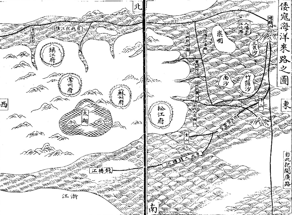 |
The map shows the estuary of the Yangtze River with some islands, and the area of the four prefectures of Songjiang (approx. today's Shanghai), Suzhou, Changzhou, and Zhenjiang. The black lines shows the routes along which the Wokou pirates used to encroach on the coast and the interior along the main rivers (Wokou haiyang lailu 倭寇海洋來路), with inscriptions like "from here they invade the southern banks" (自此犯江陰), or "from here they plunder the capital city" (自此犯京口) Nanjing 南京. The area of Qiantang River 錢塘江 is seen at the bottom of the map, but is not the focus of the book. Siku quanshu 四庫全書 edition. |
The Jiangnan jinglüe was finished in 1568. The term Jiangnan includes the four prefectures Suzhou 蘇州, Songjiang 松江, Changzhou 常州, and Zhenjiang 鎮江. Maritime prefectures were subordinated to circuits of military preparedness (wubeidao 兵備道), with clear borders of jurisdiction. The military affairs of the four prefectures in question were organised by the grand coordinator and the regional inspector of Southern Zhili province (Zhili fu-an zhu zhi 直隸撫按主之), the secondary capital (liudu 留都). Their protection against pirate raids was particularly important, even if the principal capital had been Beijing since the early 15th century.
Moreover, the southeastern provinces were the "breadbasket" of China, from where tribute grain was shipped to the north. The author was familiar with the region because he hailed from Kunshan 昆山, Jiangsu. The fight against the pirates was not just maritime (haifang 海防), but also had a fluvial character (jiangfang 江防) because the naval defence of the mid-16th century was so weak that Wokou pirates even travelled up the Yangtze and other rivers of Jiangsu and Zhejiang.
The foremost strategy (shangce 上策) of the navy was to prevent pirates from entering the estuaries of rivers, and the second strategy (zhongce 中策) to inhibit their advances upstream or infiltration of the countless waterways of the lower Yangtze area. The pirates were aware of this and therefore tried to enter rivers of lesser importance, like River Huai 淮河 or River Wusong 吳淞江 (caoxun 操巡, caojiang 操江) officers, for instance, passed on the responsibility on the provincial grand coordinators, while the latter saw the local commands in charge. Apart from the difference between land and water, the military units on the Yangtze's northern and southern banks did not cooperate. It is, therefore, quite surprising that the author only speaks of prefectures south of the Yangtze, and does not speak of those between the Yangtze and River Huai, such as Yangzhou 揚州. Zeng advocated the unified organisation of the various units of military and civil administration (guan lian 官聯), and a concentration of naval troops in the island of Chongming 崇明 (at the cost of Shanghai) to ward off the Wokou pirates and prevent them to advance further and land
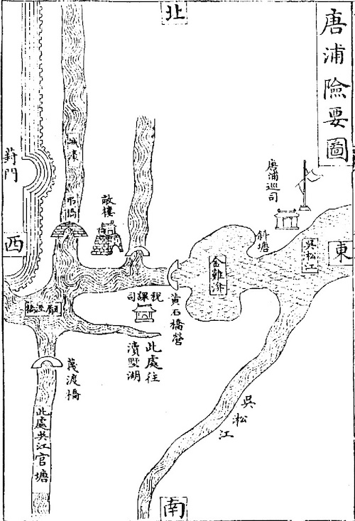 |
Important guard post (xunsi 巡司) of Tangpu 唐浦圖. Even if the map is not drawn according to scientific standards, the details clearly show how Zheng Ruozeng understood the means of defence against Wokou entering the riverine system of the lower Yangtze region. The maps shows the course of rivers and canals, dams, basins, bridges, watchtowers and government-run facilities. |
The book also talks about recruiting troops, ships, and weapons. It is richly illustrated by maps that present a vivid picture of the countless waterways by which pirates might slip far into the country to plunder the wealth of China. The maps show rivers, lakes, canals, bridges, cities, military posts, garrisons and defence structures. They are helpful, even if not drawn by scientific cartographic standards. The first of the eight chapters gives an overview of the military affairs of the maritime defence in the region, juan 2-6 specify the characteristics and necessities in the four prefectures, chapter 7 stipulates rules for military defence, and the last chapter presents military tools and tactics.
The book was first printed in 1568, and again in 1614. A further print was produced during the Kangxi reign-period 康熙 (1662-1722), which served as the blueprint for the Siku quanshu edition. A modern punctuated edition was published in 2017 by the Huangshan Press 黄山书社, with annotations by Huang Dekuan 黄德宽 and Fu Zheng 傅正.