Sep 15, 2010 © Ulrich Theobald
Zheng He hanghai tu 鄭和航海圖 "Map of Zheng He's maritime voyages" is a map drawn according to the reports of several journeys made by admiral Zheng He 鄭和 (1371-1433) during the years 1425 and 1430 of the Ming period 明 (1368-1644). The original was a map wrapped up to a scroll but is commonly printed in book shape. The first print was made in Mao Yuanyi's 茅元儀 (1594-1640) military treatises Wubeizhi 武備志 (chapter 240), on 20 pages, together with a navigation chart called Guohai xianqing tu 過海牽星圖.
The map was drawn after Zheng He returned from his sixth travel when all officials participating in the journey still stayed in the southern capital Nanjing 南京, Jiangsu, and Emperor Xuanzong 明宣宗 (the Xuande Emperor 宣德, r. 1425-1435) envisaged a seventh journey. Nanjing is the centre of the map, and the whole route is shown on to the east coast of Africa. Each country or state the travelers touched on is indicated, as well as the distance, the astronomical height, and in some places also the water depth. It is likewise indicated of which quality the shore is. The given distance from the starting point to Hormuz in the Gulf of Persia is longer than the distance back.
Figure 1. Detail from the Zheng He hanghai tu 鄭和航海圖
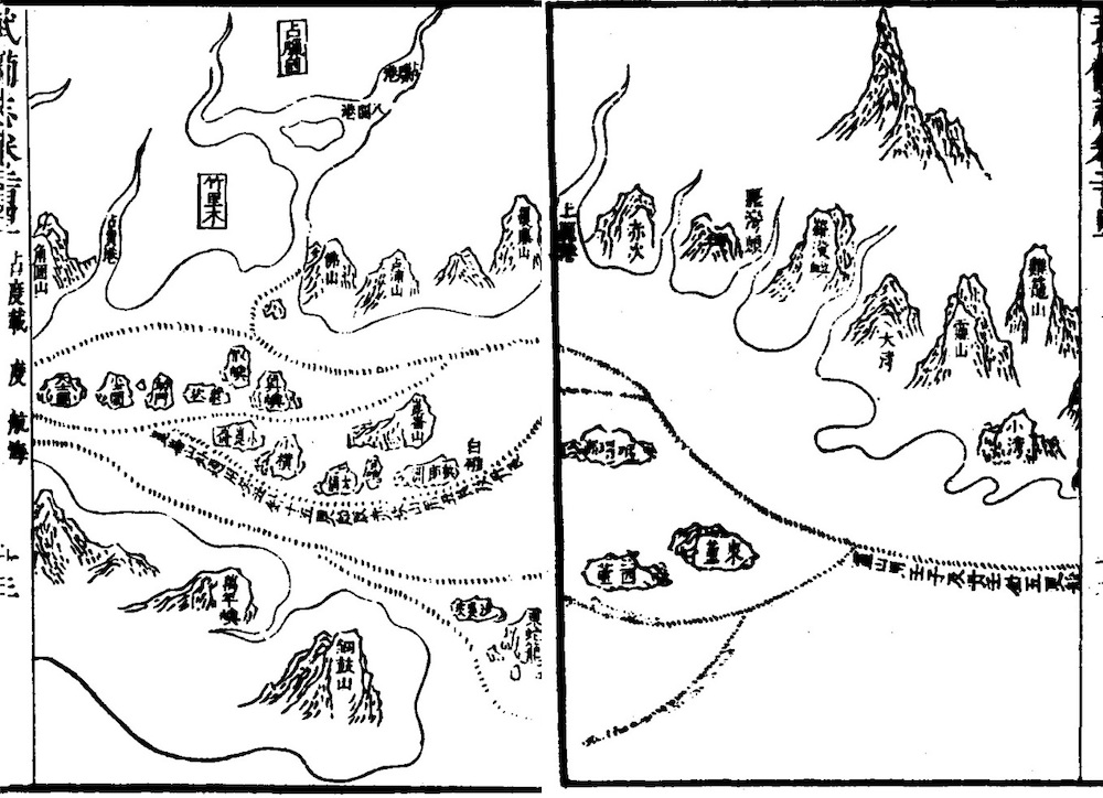 |
Image of the coast of southern Vietnam ( Champa, Ch. Zhancheng 占城), showing ports, mountains, cliffs, rocks, and possible passages, with notes. |
The map renders more than 500 names of foreign places and countries, much more than any book on foreign countries of that period. Inspite of these advantages the map is only drawn with the aspect of relative position, and not according to real scale.
Sources:
Beijing Dongfang Shoucang Xiehui 北京東方收藏家協會, ed. (1996). Zhonghua shoucang da cidian 中華收藏大辭典 (Beijing: Beijing Yanshan chubanshe), 325.
Fang Zhongfu 房仲甫 (1993). "Zheng He hanghai tu 鄭和航海圖", in Shi Quanchang 石泉長, ed. Zhonghua baike yaolan 中華百科要覽 (Shenyang: Liaoning renmin chubanshe), 188.
He Shengdi 賀聖迪 (1996). "Zheng He hanghai tu 鄭和航海圖", in Zhou Gucheng 周谷城, ed. Zhongguo xueshu mingzhu tiyao 中國學術名著提要, Vol. Keji 科技卷 (Shanghai: Fudan daxue chubanshe9, 336.
Hong Zhenquan 洪振權 (2005). "Zheng He hanghai tu jin xi 鄭和航海圖今析", Hanghai 航海, 2005 (5).
Lai Jinyi 賴進義 (2014). "Lun Zheng He hanghai tu yu haishang sichou zhi lu jian de guanxi 論《鄭和航海圖》與海上絲綢之路間的關係", Huizu yanjiu 回族研究, 2014 (8).
Haijiao shi yanjiu 海交史研究, 1988 (12).
Ren Yuhong 任余紅 (2001). "Zheng He hanghai tu 鄭和航海圖", in Huaqiao Huaren baike quanshu Zhuzuo yushu juan bianji weiyuanhui 《華僑華人百科全書·著作學術卷》編輯委員會, ed. Huaqiao Huaren baike quanshu 華僑華人百科全書, Vol. Zhuzuo yishu (Beijing: Zhongguo Huaqiao chubanshe), 600.
Tang Xiren 唐錫仁 (1992). "Zheng He hanghai tu 鄭和航海圖", in Zhongguo da baike quanshu 中國大百科全書, Vol. Dilixue 地理學 (Beijing/Shanghai: Zhongguo da baike quanshu chubanshe), 480.
Wang Zhaoming 王兆明, Fu Langyun 傅朗云, ed. (1991). Zhonghua gu wenxian da cidian 中華古文獻大辭典, Vol. Dili 地理卷 (Changchun: Jilin wenshi chubanshe), 223.
Yang Xiaohong 楊曉虹 (2006). "Shuping shijie xiancun zui zao de haitu dang'an: Zheng He hanghai tu 述評:世界現存最早的海圖檔案——《鄭和航海圖》", Dang'anxue tongxun 檔案學通訊, 2006 (3).
Zhang Jian 張箭 (2005). "JIzai Zheng He xia Xiyang de san shu yi tu: Yingya shenglan, Xingcha shengla, Xiyang fanguo tu, Zheng He hanghai tu 記載鄭和下西洋的“三書一圖”——《瀛涯勝覽》《星槎勝覽》《西洋番國志》《鄭和航海圖》", Lishi jiaoxue 歷史教學, 2005 (2).
Zhang Jian 張箭 (2005a). "Zheng He hanghai tu de fuyuan 《鄭和航海圖》的復原", Sichuan wenwu 四川文物, 2005 (4).
Zheng Hesheng 鄭鶴聲 (1992). "Zheng He hanghai tu鄭和航海圖", in Zhongguo da baike quanshu 中國大百科全書, Jiaotong 交通 (Beijing/Shanghai: Zhongguo da baike quanshu chubanshe), 635.
Zheng Hesheng 鄭鶴聲 (1992). "Zheng He hanghai tu 鄭和航海圖", in Zhongguo da baike quanshu 中國大百科全書, Part Zhongguo lishi 中國歷史 (Beijing/Shanghai: Zhongguo da baike quanshu chubanshe), Vol. 3, 1525.
Zhou Weizhou 周偉洲, Ding Jingtai 丁景泰, ed. (2006). Sichou zhi lu da cidian 絲綢之路大辭典 (Xi'an: Shaanxi renmin chubanshe), 735.
Zhou Yunzhong 周運中 (2007). "Lun Wubeizhi de Nanshuzhi zhong de Zheng He hanghai tu 論《武備志》和《南樞志》中的《鄭和航海圖》", Zhongug lishi dili luncong 中國歷史地理論叢, 2007 (4).
Zhu Hai 朱海 (1985). "Gujin duizhao Zheng He hanghai tu chuban 《古今對照鄭和航海圖》出版", Shanghai Daxue xuebao (Shehui kexue ban) 上海大學學報(社會科學版), 1985 (5).
Zhu Jianqiu 朱鑒秋 (1992). "Zheng He hanghai tu 鄭和航海圖", in Zhongguo da baike quanshu 中國大百科全書, Part Guti diqiu wulixue, cehuixue, kongjianxue 固體地球物理學·測繪學·空間學 (Beijing/Shanghai: Zhongguo da baike quanshu chubanshe), 447.