ChinaKnowledge.de -
An Encyclopaedia on Chinese History and Literature
Da-Qing yitong zhi 大清一統志 "Records of the Unity of the Great Qing" is the imperial geography of the Qing empire 清 (1644-1911). A description of the whole empire was an important and desirable task for each greater dynasty in China. The imperial geography of the Qing empire was several times rearranged before a final version was finished in 1744. The first version was started in 1686 under the guidance of Xu Qianxue 徐乾學 (1631-1694). The 1744 version had a size of 342 juan.
Several changes in administration, especially in the border regions, made necessary a second edition that was published in 1784, the 424 juan-long version from the Qianlong reign-period 乾隆 (1736-1795). Again, great changes in population structure - and thus in the structure of administative and fiscal organisation - led to a third version of the Da-Qing yitong zhi finished in 1842, the so-called Jiaqing 嘉慶 version in 560 juan (called so because it was begun in 1812, during the Jiaqing reign-period, 1796-1820).
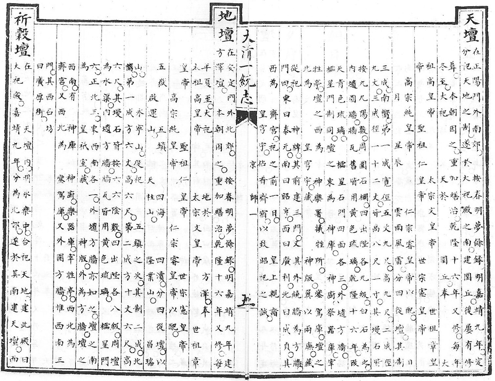
Beginning with the capital Beijing, the imperial geography describes every province and prefecture of the Qing empire, ending with the border regions and the tributary states. The geographical description for each location, be it a province (sheng 省), a prefecture (fu 府, zhou 州), or a district (xian 縣), follows more or less a fix pattern. Each chapter begins with a map (tu 圖) and a table (biao 表 with geographical and chronological overview, and then describes borders to neighbouring units (jiangyu 疆域), the starry sky at the location (fenye 分野), administrative history (jianzhi yange 建置沿革), topography (xingshi 形勢), local customs (fengsu 風俗), city walls and moats (chengchi 城池), schools (xuexiao 學校), household numbers (hukou 戸口), field tax revenue (tianfu 田賦), other levies (shuike 税課), offices (zhiguan 職官), mountains and rivers (shanchuan 山川), historic places (guji 古蹟), passes (guan'ai 關隘), fords and bridges (jinliang 津梁), dams and dykes (diyan 隄堰), tomb hills and graves (lingmu 陵墓), shrines (cimiao 祠廟, Buddhist and Daoist temples (siguan 寺觀), famous officials (minghuan 名宦), illustrious persons (renwu 人物), foreign residents (liuyu 流寓), outstanding females (lienü 列女), noted immortals and monks (xianshi 仙釋), and local products (tuchan 土產).
 |
 |
 |
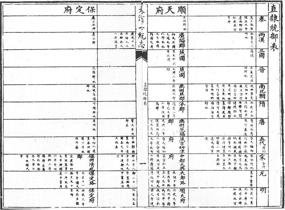 |
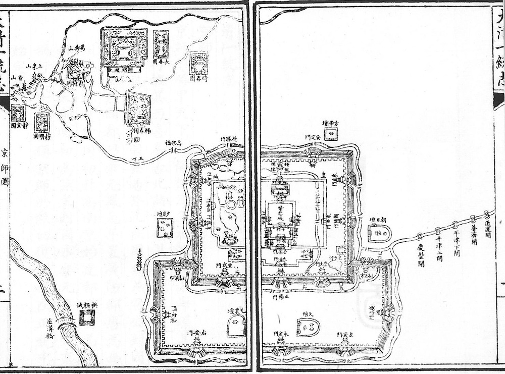
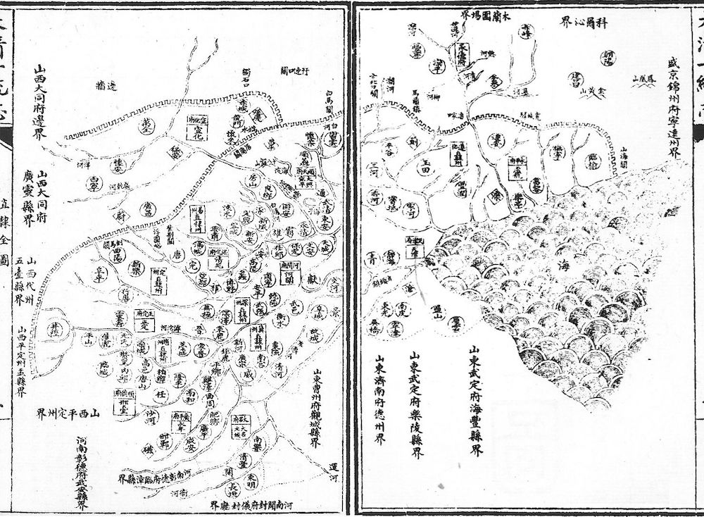
Top left: Map of Jingshi 京師 (Beijing). Top right: Description of the Temple of Heaven (Tiantan 天壇) and the Temple of the Earth (Ditan 地壇). Bottom left: Map of the province of Zhili 直隸 (today's Hebei), with the Great Wall and adjacent prefectures. Bottom right: Chronological overview table of the province of Zhili, from the Qin 秦 (221-206 BCE) to the Ming period 明 (1368-1644), first for the province, then for each prefecture. From the Jiaqing chongxiu Da-Qing yitong zhi 嘉慶重修大清一統志, edition Sibu congkan xubian 四部叢刊續編. |
|
| 1-4 | 京師 The Capital (Beijing) | |
| 5-56 | 直隸 Province of Zhili | First-class prefectures of Shuntian 順天府, Baoding 保定府, Yongping 永平府, Hejian 河間府, Tianjin 天津府, Zhengding 正定府, Shunde 順德府, Guangping 廣平府, Daming 大名府, Xuanhua 宣化府, Yongde 承德府; second-class prefectures of Zunhua 遵化州, Yizhou 易州, Jizhou 冀州, Zhaozhou 趙州, Shenzhou 深州, Dingzhou 定州 |
| 57-71 | 盛京 Province of Shengjing | Secondary capital Shengjing 興京 (Shenyang 瀋陽), first-class prefectures of Fengtian 奉天府, Jinzhou 錦州府; regions Jilin 吉林, Heilongjiang 黑龍江 |
| 72-107 | 江蘇 Province of Jiangsu | First-class prefectures of Jiangning 江寧府 (Nanjing), Suzhou 蘇州府, Songjiang 松江府, Changzhou 常州府, Zhenjiang 鎮江府, Huai'an 淮安府, Yangzhou 揚州府, Xuzhou 徐州府; second-class prefectures of Taicang 太倉州, Haizhou 海州, Tongzhou 通州; subprefecture of Haimen 海門廳 |
| 108-134 | 安徽 Province of Anhui | First-class prefectures of Anqing 安慶府, Huizhou 徽州府, Ningguo 寧國府, Chizhou 池州府, Taiping 太平府, Luzhou 廬州府, Fengyang 鳳陽府, Yingzhou 穎州府; second-class prefectures of Chuzhou 滁州, Hezhou 和州, Guangde 廣德州, Liu'an 六安州, Sizhou 泗州 |
| 135-160 | 山西 Province of Shanxi | First-class prefectures of Taiyuan 太原府, Pingyang 平陽府, Puzhou 蒲州府, Lu'an 潞安府, Fenzhou 汾州府, Zezhou 澤州府, Datong 大同府, Ningwu 寧武府, Shuoping 朔平府; second-class prefectures of Pingding 平定州, Xinzhou 忻州, Daizhou 代州, Baode 保德州, Huozhou 霍州, Xiezhou 解州, Jiangzhou 絳州, Qinzhou 沁州, Liaozhou 遼州; six subprefectures of Guihua (Köke Qota) 歸化城六廳 |
| 161-184 | 山東 Province of Shandong | First-class prefectures of Jinan 濟南府, Yanzhou 兖州府, Dongchang 東昌府, Qingzhou 青州府, Dengzhou 登州府, Laizhou 萊州府, Wuding 武定府, Yizhou 沂州府, Tai'an 泰安府, Caozhou 曹州府, Jining 濟寧州, Linqing 臨清州 |
| 185-225 | 河南 Province of Henan | First-class prefectures of Kaifeng 開封府, Chenzhou 陳州府, Guide 歸德府, Zhangde 彰德府, Weihui 衛輝府, Huaiqing 懷慶府, Henan 河南府, Nanyang 南陽府, Runing 汝寧府; second-class prefectures of Xuzhou 許州, Shaanzhou 陜州, Guangzhou 光州, Ruzhou 汝州 |
| 226-250 | 陜西 Province of Shaanxi | First-class prefectures of Xi'an 西安府, Yan'an 延安府, Fengxiang 鳳翔府, Hanzhong 漢中府, Yulin 榆林府, Xing'an 興安府, Tongzhou 同州府; second-class prefectures of Shangzhou 商州, Qianzhou 乾州, Binzhou 邠州, Luzhou 鄜州, Suide 綏德州 |
| 251-280 | 甘肅 Province of Gansu | First-class prefectures of Lanzhou 蘭州府, Gongchang 鞏昌府, Pingliang 平涼府, Qingyang 慶陽府, Ningxia 寧夏府, Ganzhou 甘州府, Liangzhou 涼州府, Xining 西寧府, Zhenxi 鎮西府; second-class prefectures of Jingzhou 涇州, Qinzhou 秦州, Jiezhou 階州, Suzhou 肅州, Anxi 安西州, Dihua 迪化州 |
| 281-306 | 浙江 Province of Zhejiang | First-class prefectures of Hangzhou 杭州府, Jiaxing 嘉興府, Huzhou 湖州府, Ningbo 寧波府, Shaoxing 紹興府, Taizhou 台州府, Jinhua 金華府, Quzhou 衢州府, Yanzhou 嚴州府, Wenzhou 溫州府, CHuzhou 處州府; subprefecture of Yuhuan 玉環廳 |
| 307-333 | 江西 Province of Jiangxi | First-class prefectures of Nanchang 南昌府, Raozhou 饒州府, Guangxin 廣信府, Nankang 南康府, Jiujiang 九江府, Jianchang 建昌府, Fuzhou 撫州府, Linjiang 臨江府, Ruizhou 瑞州府, Yuanzhou 袁州府, Ji'an 吉安府, Ganzhou 贛州府, Nan'an 南安府; second-class prefecture of Ningdu 寧都州 |
| 334-352 | 湖北 Province of Hubei | First-class prefectures of Wuchang 武昌府, Hanyang 漢陽府, Huangzhou 黄州府, Anlu 安陸府, De'an 德安府, Jingzhou 荊州府, Xiangyang 襄陽府, Yunyang 鄖陽府, Yichang 宜昌府, Shinan 施南府; second-class prefecture of Jingmen 荊門州 |
| 353-382 | 湖南 Province of Hunan | First-class prefectures of Changsha 長沙府, Yuezhou 岳州府, Baoqing 寶慶府, Hengzhou 衡州府, Changde 常德府, Chenzhou 辰州府, Yuanzhou 沅州府, Yongzhou 永州府, Yongshun 永順府; second-class prefectures of Lizhou 澧州, Guiyang 桂陽州, Jingzhou 靖州, Chenzhou 郴州; subprefectures of Qianzhou 乾州廳, Fenghuang 鳳凰廳, Yongsui 永綏廳, Huangzhou 晃州廳 |
| 383-423 | 四川 Province of Sichuan | First-class prefectures of Chengdu 成都府, Chongqing 重慶府, Baoning 保寧府, Shunqing 順慶府, Xuzhou 敘州府, Kuizhou 夔州府, Long'an 龍安府, Ningyuan 寧遠府, Yazhou 雅州府, Jiading 嘉定府, Tongchuan 潼川府, Suiding 綏定府; second-class prefectures of Meizhou 眉州, Qiongzhou 邛州, Luzhou 瀘州, Zizhou 資州, Mianzhou 綿州, Maozhou 茂州, Zhongzhou 忠州, Youyang 酉陽州; subprefectures of Xuyong 敘永廳, Songpan 松潘廳, Shizhu 石砫廳, Zagu 雜谷廳, Taiping 太平廳, Maogong 懋功廳 |
| 424-439 | 福建 Province of Fujian | First-class prefectures of Fuzhou 福州府, Xinghua 興化府, Quanzhou 泉州府, Zhangzhou 漳州府, Yanping 延平府, Jianning 建寧府, Shaowu 邵武府, Dingzhou 汀州府, Fujing 福寧府, Taiwan 臺灣府; second-class prefectures of Yongchang 永春州, Longyan 龍巖州 |
| 440-459 | 廣東 Province of Guangdong | First-class prefectures of Guangzhou 廣州府, Shaozhou 韶州府, Huizhou 惠州府, Chaozhou 潮州府, Zhaoqing 肇慶府, Gaozhou 高州府, Lianzhou 廉州府, Leizhou 雷州府, Qiongzhou 瓊州府; second-class prefectures of Nanxiong 南雄州, Lianzhou 連州, Jiaying 嘉應州, Luoding 羅定州; subprefectures of Fogang 佛岡廳, Lianshan 連山廳 |
| 460-474 | 廣西 Province of Guangxi | First-class prefectures of Guilin 桂林府, Liuzhou 柳州府, Qingyuan 慶遠府, Si'en 思恩府, Sicheng 泗城府, Pingle 平樂府, Wuzhou 梧州府, Xunzhou 潯州府, Nanning 南寧府, Taiping 太平府, Zhen'an 鎮安府; second-class prefecture of Yulin 鬱林州 |
| 475-498 | 雲南 Province of Yunnan | First-class prefectures of Yunnan 雲南府 (Kunming), Dali 大理府, Lin'an 臨安府, Chuxiong 楚雄府, Chengjiang 澂江府, Guangnan 廣南府, Shunning 順寧府, Qujing 曲靖府, Lijiang 麗江府, Pu'er 普洱府, Yongchang 永昌府, Kaihua 開化府, Dongchuan 東川府, Zhaotong 昭通府, Guangxi 廣西府, Wuding 武定府, Yuanjiang 元江府; second-class prefecture of Zhenyuan 鎮沅州; subprefectures of Jingdong 景東廳, Menghua 蒙化廳, Yongbei 永北廳, Tengyue 騰越廳 |
| 499-515 | 貴州 Province of Guizhou | First-class prefectures of Guiyang 貴陽府, Anshun 安順府, Duyun 都勻府, Zhenyuan 鎮遠府, Sinan 思南府, Shiqian 石阡府, Sizhou 思州府, Tongren 銅仁府, Liping 黎平府, Dading 大定府, Xingyi 興義府, Zunyi 遵義府; second-class prefecture of Pingyue 平越州; subprefectures of Songtao 松桃廳, Pu'an 普安廳, Renhuai 仁懷廳 |
| 516-531 | 新疆 Xinjiang | Yili 伊犂, Kurkela Usu 庫爾喀喇烏蘇, Tarbahatai 塔爾巴哈台, Ürümqi 烏嚕木齊, Ancient City 古城, Balikun 巴里坤, Hami 哈密, Turfan 吐魯番, Qara Shar 喀喇沙爾, Kuche 庫車, Aksu 阿克蘇, Uš 烏什, Kašgar 喀什噶爾, Yarkant 葉爾羌, Qotan 和闐, Left Kazaks 左哈薩克, Right Kazaks 右哈薩克, Eastern Burut 東布魯特, Western Burut 西布魯特, Kokand 霍罕, Andijon 安集延, Margilon 瑪爾噶朗, Namangan 那木干, Tašhan 塔什罕, Badakhshan 拔達克山, Gilgit 博洛爾, Bokhara 布哈爾, Afghanistan 愛烏罕, Hindostan 痕都斯坦, Baltistan 巴勒提 |
| 532-533 | Uliyasutai 烏里雅蘇台, Kulun 庫倫, Kobdo 科布多 | |
| 534 | 蒙古 Mongols | Tümed 土黙特, Aoqan 敖漢, Naiman 柰曼, Baɣarin 巴林, Jarud 扎嚕特, Aru Qorčin 阿嚕科爾沁, Qorčin 科爾沁, Jalaid 扎賚特, Dörbed 杜爾伯特, Gorlos 郭爾羅斯, Qaracin 喀喇沁, Ongniɣud 翁牛特, Kesigten 克什克騰, Left-Wing Qalqa 喀爾喀左翼, Üjumüčin 烏珠穆沁, Qaɣučid 浩齊特, Sünid 蘇尼特, Abaɣa 阿巴噶, Abaɣanar 阿巴哈納爾, Dörben Keüked 四子部落, Muumingɣan 茂明安, Urad 烏喇特, Right-Wing Qalqa 喀爾喀右翼, Ordos 爾多斯, Qalqa 喀爾喀, Alaša Oyirad 阿拉善厄魯特, Qinghai Oyirad 青海厄魯特 |
| 547 | 西藏 Tibet | |
| 548 | Tümed from Köke Qota (Guihua) 歸化城土黙特, pastures 牧廠 | |
| 549 | Čaqar 察哈爾 | |
| 550 | Korea 朝鮮 | |
| 551 | Ryūkyū 琉球, Holland 荷蘭 | |
| 552 | Western Ocean 西洋, Siam 暹羅 | |
| 553 | Vietnam 越南 | |
| 554 | Russia 俄羅斯 | |
| 555 | Lane Xang (Laos) 南掌, Sulu 蘇祿, Japan 日本, Luzon 呂宋 | |
| 556 | Myanmar 緬甸, England {口英}咭唎, "Zhengqian" 整欠, "Gourd Country" 葫蘆國, Banjarmasin 馬辰 | |
| 557 | Gangkou 港口, Guangnan 廣南, Johor 柔佛, Pahang 彭亨, Dingjinu 丁機奴, Ruiguo {口瑞}國, Lianguo 嗹國, Maliujia 嘛六甲, Songjulao 宋腒朥 | |
| 558 | "Hamaoli" 合貓里, Maluku Islands 美洛居, "Wencai" 汶菜, Bengal 榜葛刺, "Fulin" 拂菻, Calicut 古里 | |
| 559 | Cochin 柯枝, Sri Lanka 錫蘭山, Suoli in the Western Ocean 西洋瑣里, Aceh 啞齊, Lamuri 南渤利, Champa 占城, Cambodia 柬埔寨 | |
| 560 | Galaba 噶喇巴 (Jakarta), Brunei 渤泥, Belitung Island 麻葉甕, Old Port 舊港, "France" 法蘭西 |