|
Periods of Chinese History
|
 |
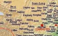
The Sui dynasty was, after long centuries of division, the first to reconquer the whole territory of China. The old cities of Chang'an 長安 (modern Xi'an
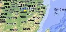
西安, Shaanxi) and Luoyang 洛陽 (modern Luoyang, Henan) were again chosen as the capitals, but the economical overweight of the Yangtze River delta
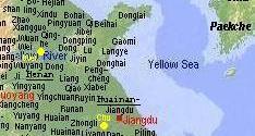
region led to the founding of a third capital, Jiangdu 江都 (modern
Yangzhou 揚州, Jiangsu). The imperial canal stretched
from the lower Yangtze area to the capitals in the north to ensure their supply with grain.
The Sui government took over the traditional local administration in
regions or provinces (zhou 州) and subordinated commanderies (jun
郡) that had been in common use since Qin
秦 (221-206 BCE) and Han
漢 (206 BCE-220 CE) times. Although most names of commanderies had not been changed
since, the names of the regions were altered now under the Sui
administration, many of these names were later used as names of
provinces.
|
The regions or provinces (zhou 州) of the Sui empire
|
| region |
modern location |
| Guan-Long 關隴 |
Shaanxi |
| Hexi 河西 |
Gansu, Ningxia |
| Hedong 河東 |
Shanxi |
| Hebei 河北 |
Hebei, Beijing, Tianjin |
| Henan 河南 |
Henan, Shandong |
| Liaoxi 遼西 |
Liaoning |
| Huainan-Jiangbiao 淮南江表 |
Jiangsu, Shanghai, Anhui, Zhejiang, Fujian |
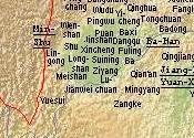
| Ba-Han 巴漢 |
eastern Sichuan, Chongqing |
| Min-Shu 岷蜀 |
western Sichuan |
| Jiang-Han-Yuan-Xiang 江漢沅湘 |
Hubei, Hunan, Guandong, Jiangxi |
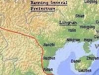
| Lingnan 嶺南 |
Guangxi, Hainan, north of modern Vietnam |
| General Prefecture Nanning 南寧州總管府 |
Yunnan, Guizhou |
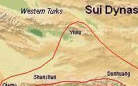  
The Sui dynasty
was the first to establish regular commanderies beyond
the Gansu corridor in Yiwu 伊吾 (modern Hami 哈密, Xinjiang), Shanshan 鄯善
(Ruoqiang 若羌), Qiemo 且末, Xihai 西海 (Lake Qinghai 青海), and Heyuan 河源
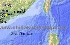
(Xinghai 興海, Qinghai). The mountainous region of modern Yunnan was
loosely administered as General Prefecture of Nanning 南寧州總管府. In this
area the kingdom of Nanzhao
南詔 took shape. The Sui territory now stretched from the eastern
Tarim Basin in the west to the Liaodong Peninsula in the east and from the northern
loop of the Yellow River down south to the northern parts of Vietnam and Hainan
Island 海南島.
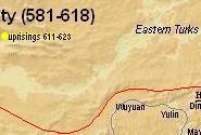
In the last decade of the Sui, between 611 and 623, numerous uprisings
and rebellions took place, especially in the area of the lower Yellow
River course (in the map yellow dots). Here, military leaders proclaimed their own dynasties,
like Wei 魏 (by Li Mi 李密), Chu 楚, Xia 夏 (Dou Jiande 窦建德), Yan 燕, Zheng
鄭, Liang 梁, and Tang (Li Yuan 李淵).
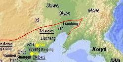
Neighbours of the Sui empire in the north was the khanate of the Türks (Tujue 突厥) that fell apart into the Eastern and the Western Türkish khanates in 581. More to the
east were the inhabitants of the Northeastern Plain, the Khitans 契丹, the Xi 奚, and the Shiwei 室韋.
The Changbaishan Mountain Range was inhabited by people of the Mohe
靺鞨. On the Korean Peninsula the Three Kingdoms (Samguk 三國)
had taken shape: Koguryŏ/Gaogouli 高句麗, Paekche/Baiji 百濟, and
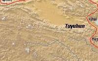
Silla/Xinluo 新羅. In modern Qinghai, the state of the proto-Mongol Tuyuhun
吐谷渾 controled the region.
2000 ff. © Ulrich Theobald · Mail
|
|

Map and Geography

Event History

Emperors and Rulers
(Tang)
Government and Administration

Literature and Philosophy

Religion

Technology and Inventions

Economy

Arts
|
