|
Periods of Chinese History
|
 |
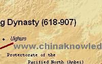
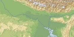
The Tang empire 唐 (618-907) was the second of the Chinese empires that had a subcontinental size (the first being the Han, the third the Yuan and the fourth the Qing empire). The Tang empire stretched from the Pamir Range in the west to the Korean Peninsula in the east, and
from the Mongolian steppe down to what is modern Vietnam.
The Tang capital was Chang'an 長安 (modern Xi'an 西安, Shaanxi), with several secondary capitals:
The Capitals of the Tang Empire |
| capital |
prefecture |
modern place |
| (main capital) |
Chang'an 長安 |
Xi'an 西安, Shaanxi |
| Zhongdu 中都 "Cental Capital" |
Hezhong 河中 |
Yongji 永濟, Shanxi |
| Dongdu 東都 "Eastern Capital" |
Luoyang 洛陽 |
Luoyang, Henan |
| Xidu 西都 "Western Capital" |
Fengxiang 鳳翔 |
Fengxiang/Shaanxi |
| Beidu 北都 "Northern Capital" |
Taiyuan 太原 |
Taiyuan, Shanxi |
| Nandu 南都 "Southern Capital" |
Chengdu 成都 (later Jiangling 江陵) |
Chengdu, Sichuan (Jiangling, Hubei) |
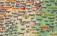
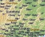
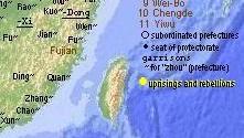
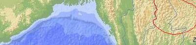
The whole empire was divided
into ten "circuits" or provinces (later more; called dao 道; in the map written in courier type
underlined) with subordinated prefectures (zhou
州; in the map abbreviated with the symbol ~) and superior prefectures (fu 府, a
few areas
mostly around the capitals). Many names of the Tang period prefectures survive in the name of modern cities, like Yangzhou 揚州, Hangzhou 杭州, Guangzhou 廣州 etc. In the western and southern border regions
there were many inferior prefectures headed by submissive chieftains of
Non-Chinese tribes (in the map signified by a circle).
The Circuits or Provinces (dao 道) of the Tang Empire |
| circuit (prefectural seat) | modern location |
| Jingji 京畿道 (Jingzhaofu 京兆府=Chang'an 長安) | southern Shaanxi |
| Guannei 關內道 (dir. adm.) | northern Shaanxi |
| Duji 都畿道 (Henanfu 河南府=Luoyang 洛陽) | western Henan |
| Henan 河南道 (Bianzhou 汴州) | eastern Henan, Shandong |
| Hedong 河東道 (Puzhou 蒲州) | Shanxi |
| Hebei 河北道 (Pinglu 平盧=Yingzhou 營州) | Hebei, Beijing, Tianjin |
| Longyou 隴右道 (Shanshou 鄯州) | Gansu, Ningxia |
| Shannan-Dong 山南東道 (Xiangzhou 襄州) | Hubei |
| Shannan-Xi 山南西道 (Liangzhou 梁州) | Sichuan, Chongqing |
| Huainan 淮南道 (Yangzhou 揚州) | northern Jiangsu, northern Anhui |
| Jiangnan-Dong 江南東道 (Suzhou 蘇州) | southern Jiangsu, southern Anhui, Shanghai, Zhejiang, Fujian |
| Jiangnan-Xi 江南西道 (Hongzhou 洪州) | Jiangxi, eastern Hunan |
| Qianzhong 黔中道 (Qianzhou 黔州) | western Hunan, Guizhou |
| Jiannan 劍南道 (Yizhou 益州=Chengdufu 成都府) | southern Sichuan |
| Lingnan 嶺南道 (Guangzhou 廣州) | Guangxi, Guangdong, Hainan |
 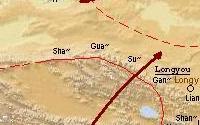  
   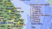
From the year 806 on the civil administratorial structure of the
circuit was superposed with the militarian structure of defence
commands (fangzhen 方鎮 or fanzhen
藩鎮; in the map
in brown color) headed by military commissioners (jiedushi
節度使; similar titles were: surveillance
commissioner guanchashi 觀察使,
examination commissioner anchashi 按察使,
investigation commissioner caifangshi 採訪使, regulatory commissioner jinglüeshi
經略使, or defence
commissioner fangyushi 防禦使).
The Defence Commands (fanzhen 藩鎮) of the Tang Dynasty |
North (seat):
Tongzhou 同州防禦使
(Tongzhou 同州)
Tongguan 潼關防禦使
(Huazhou 華州)
Fu-Fang 鄜房節度使 (Fuzhou 鄜州)
Bin-Ning 邠寧節度使 (Binzhou 邠州)
Jing-Yuan 涇原節度使 (Jingzhou 涇州)
Fengxiang 鳳翔節度使 (Fengxiangfu 鳳翔府)
Shuofang 朔方節度使 (Lingzhou 靈州)
Xia-Sui 夏綏節度使 (Xiazhou 夏州)
Fengzhou 豐州防禦使
(Tiandejun 天德軍)
Shaan-Guo 陜虢觀察使
(Shaanzhou 陜州)
Hezhong 河中節度使 (Hezhongfu 河中府)
Dongduji 東都畿都防禦使
(Henanfu 河南府)
Heyang Sancheng 河陽三城節度使 (Huaizhou 懷州)
Yichengjun 義成軍節度使 (Huazhou 滑州)
Zhongwujun 忠武軍節度使 (Xuzhou 許州)
Xuandejun 宣德軍節度使 (Bianzhou 汴州)
Wuningjun 武寧軍節度使 (Xuzhou 徐州)
Yanhai 兖海節度使 (Yanzhou 兖州)
Pinglu 平盧節度使 (Qingzhou 青州)
Zhaoyijun 昭義軍節度使 (Luzhou 潞州)
Wei-Bo 魏博節度使 (Weizhou 魏州)
Tianpingjun 天平軍節度使 (Yunzhou 鄆州)
Hedong 河東節度使 (Taiyuanfu 太原府)
Chengdejun 成德軍節度使 (Zhenzhou 鎮州)
Henghaijun 橫海軍節度使 (Yichangjun 義昌節度使; Canghai 滄海)
Yiwujun 義武軍節度使 (Dingzhou 定州)
Zhenwu 振武節度使 (Datongjun 大同軍防禦使;
Chanyufu 單于府)
Lulongjun 盧龍軍節度使 (Youzhou 幽州)
Northwest:
Longyou 隴右節度使 (Shanzhou 鄯州)
Qinzhou 秦州節度使 (Qinzhou 秦州)
Hexi 河西節度使 (Liangzhou 涼州)
Gua-Sha 瓜沙節度使 (Shazhou 沙州)
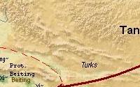
Beiting 北庭節度使 (Tingzhou 庭州)
Anxi 安西節度使 (Qiuci zhen 龜茲鎮)
South:
Zhexi 浙西觀察使 (Runzhou
潤州)
Zhedong 浙東觀察使
(Yuezhou 越州)
Xuan-She 宣歙觀察使
(Xuanzhou 宣州)
Huainan 淮南節度使 (Yangzhou 揚州)
E-Yue 鄂嶽觀察使 (Wuchang
武昌節度使; Ezhou 鄂州)
Jiangxi 江西觀察使
(Hongzhou 洪州)
Fuzhou 福州觀察使 (Fujian
福建)
Jingnan 荊南節度使 (Jianglingfu 江陵府)
Hunan 湖南觀察使 (Tanzhou
潭州)
Shannan-Xidao 山南西道節度使 (Xingyuanfu 興元府)
Jin-Shang 金商都防禦使
(Jinzhou 金州)
Qianzhou 黔州觀察使
(Qianzhou 黔州)
Jiannan-Dongchuan 劍南東川節度使 (Zizhou 梓州)
Jiannan-Xichuan 劍南西川節度使 (Chengdufu 成都府)
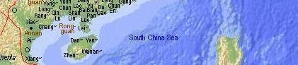
Gui 貴管經略使 (Guizhou
貴州)
Rong 容管經略使 (Rongzhou
容州)
Yong 邕管經略使 (Yongzhou
邕州)
Lingnan 嶺南節度使 (Guangzhou 廣州)
Annan 安南經略使
(Jiaozhou 交州) |
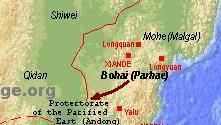
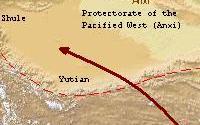
The neighbouring
regions of the Tang empire were administered as
protectorates (duhufu 都護府) after the pacification by
the Tang armies. There was an eastern, northern, western and southern
protectorate (Andong 安東, Anbei
安北, Anxi 安西 and Annan duhufu
安南都護府; the last designation is the origin of the name Annam for
northern Vietnam)
whose seats changed over time. There existed also a handful of smaller
protectorates in the north, like Yanran 燕然, Chanyu 單于, and Beiting 北庭.
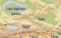
The city states of the Tarim Basin along the Silk Road
became Chinese garrisons, especially the four cities of Yanqi 焉耆, Qiuci
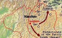
龜茲, Shule 疏勒, and Yutian 于闐, the so-called four defence commands (sizhen 四鎮) of the Protectorate of the Pacified West (Anxi duhufu 安西都護府). All protectorates were lost during the 9th
century. As a subordinated administration unit, submissive chieftains
of foreign peoples and tribes were made commander-in-chief (dudu
都督) reigning their territory and people in the name of Tang as area
command (dudufu 都督府). This method of bestowing
official titles of China to neighbouring chieftains makes Tang China
much larger as it indeed was.
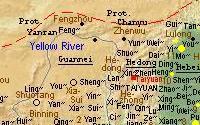
The Tang empire was heavily shaken in its grounds during the
rebellion of An Lushan 安祿山 (703-757) and Shi Siming 史思明 in the years of 755-759
and 759-763 that originated in the area of modern Beijing but effected
the whole northern plain and devastated the capitals Chang'an and
Luoyang. From the beginning of the 9th century several defence commands -
especially in the region north of the Yellow River - rebelled against
the Tang government (small yellow dots in the map), in 859-60 Qiu Fu 裘甫 rose up in
Zhedong (modern Zhejiang), and in 868-69 Pang Xun 龐勛 in Huainan (modern
Jiangsu), but much greater was the rebellion of Wang Xianzhi 王仙芝 and
Huang Chao 黃巢 at the lower Yellow River course in the decade 874-884.
The northern neigbours of the Tang empire were Türkish tribes, first the
confederation of the Türks
(Tujue 突厥) and later various peoples like the
Qarluqs (Geluolu 葛邏祿) and Türgiš (Tuqishi 突騎施), and later the
new mighty federation of the Uyghurs
(Huihe 回紇, Huigu 回鶻) that took over the city states of the Tarim Basin
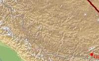
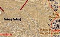
in the 10th century. In the Tibetan highland the empire of Tubo 吐藩 developed to a powerful challenger of the
Chinese authority. Tubo armies conquered the whole west at the beginning of
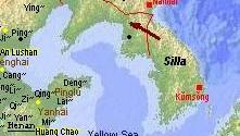
the 9th century. In the southeast of Tang China hilltribes (sometimes said to be
ancestors of the modern Thais) were united in the kingdom of Nanzhao 南詔
that occupied modern Yunnan and the north of Laos, Thailand and Myanmar.
In the northeast the Korean
kingdom of Silla (Xinluo 新羅) expanded to the north, and in the eastern
zone of the Northeastern Plain the kingdom of Bohai 渤海 expanded. In the far south the Cambodian kingdom of Zhenla
真臘 had expanded to the north almost to the border of the Tang
prefectures.
2000 ff. © Ulrich Theobald · Mail
|
|

Map and Geography

Event History

Emperors and Rulers
Government and Administration

Literature and Philosophy

Religion

Technology and Inventions

Economy

Arts
|
